Before bottleneck traffic and the modern housing crisis, San Diego was a swath of undeveloped land, horse-drawn carriages, and dairy farms. We look at 10 iconic locations from the late 1800s to mid-1900s that show just how much (and in some cases how little) our city has changed over the years.
Photos Courtesy of the San Diego History Center
Vintage San Diego: How Our City Has Changed Since 1876
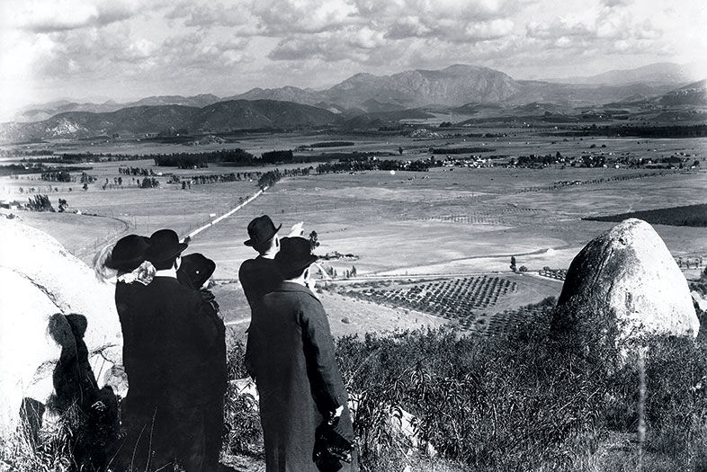
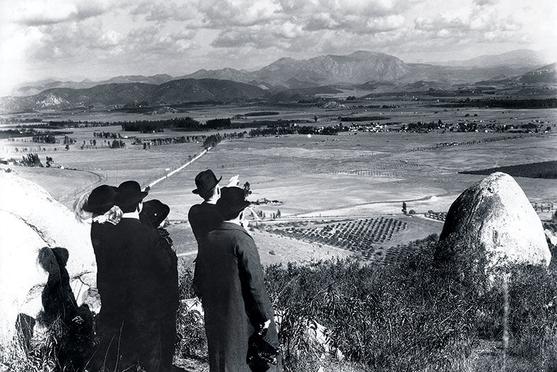
c. 1910
La Mesa
Near Summit Circle
An unidentified group looks toward El Cajon. The two gentlemen on the right could likely be business partners Ed Fletcher and William Gross, showing their development-ready land to potential buyers. Pennsylvania-born Gross was a theater agent and actor interested in establishing an artists’ colony, which was in fashion at the turn of the last century (for a time, composers and touring performers kept homes in the La Mesa area). Gross made no secret of his admiration for Fletcher’s sister Bess, and, perhaps as a gesture of appreciation, it was she who suggested the name “Grossmont.”
Vintage San Diego: How Our City Has Changed Since 1876
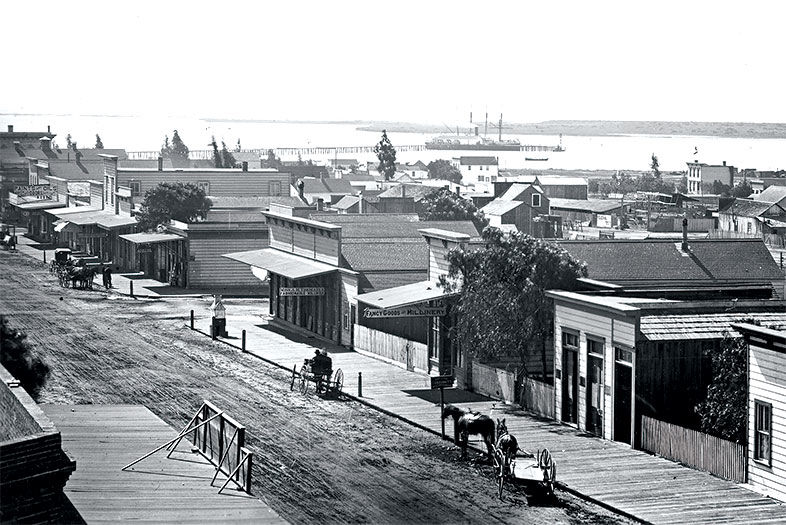
1876
Gaslamp Quarter
Fifth Avenue and Broadway
With the country still in Reconstruction after the Civil War, San Diego’s elite were desperately lobbying for a transcontinental railroad to run south of the Rockies and bring investors, developers, and commerce, which would ultimately raise property values. In 1871, businessman E. W. Morse wrote, “We are suffering another drouth this year, but if the railroad bill passes we can stand it, but if that fails God help us.”
Several obstacles got in the way, namely competition from the Central Pacific route, too few land grants, and an overall bust-and-boom financial climate. San Diegans never got their railroad, and they would have to wait another forty-two years for the Panama Canal to open, making San Diego the first port of call on the U.S. West Coast.
Vintage San Diego: How Our City Has Changed Since 1876
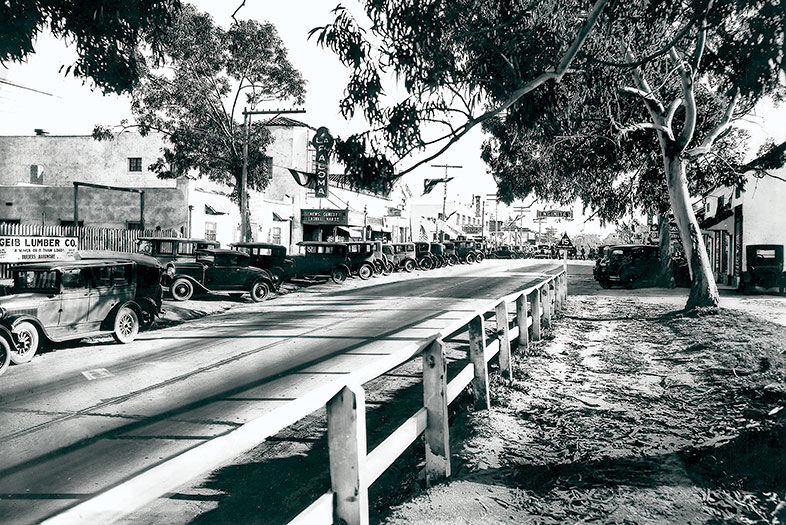
1929
Encinitas
Highway 101
La Paloma Theatre, which opened 12 months before this photo was taken and still stands today, welcomes patrons with its grand marquee. Though talkies debuted the same year as La Paloma, the theater’s owner installed a pipe organ for all the silent movies still being produced. (Notice that the sign reads, “News. Comedy Laurel Hardy.”) In those days, Highway 101 was the only road to Los Angeles, as I-5 would not be completed in its entirety until 1979.
Vintage San Diego: How Our City Has Changed Since 1876
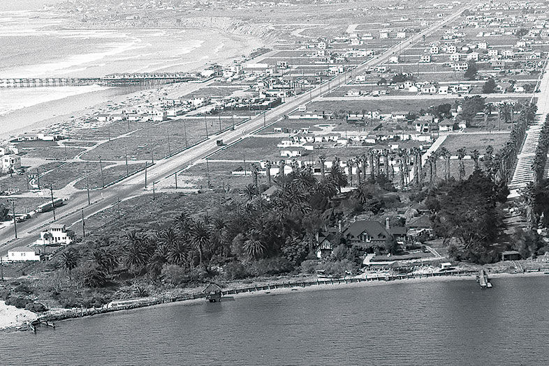
1945
Sail Bay and Pacific Beach
The site of the Catamaran Resort Hotel and Spa was once home to Emma Jessop and Frederick Tudor Scripps. He was the brother of newspaper magnate E. W. Scripps and the half brother of Ellen Browning Scripps. Look closely at the pointed, Tudor-style roof among the fruit orchards at the bottom of the photo—this was the home’s formal dining room. When the hotel came along, this section of the house was transformed into the Catamaran Wedding Chapel.
Decades later, hotel expansion would force it out, but preservationists saved the structure and eventually relocated it to the base of Mount Soledad. If it looks familiar, that’s because it’s now the wedding chapel known as Rose Creek Cottage on Garnet Avenue.
Vintage San Diego: How Our City Has Changed Since 1876
1934
La Mesa
Mount Helix Park
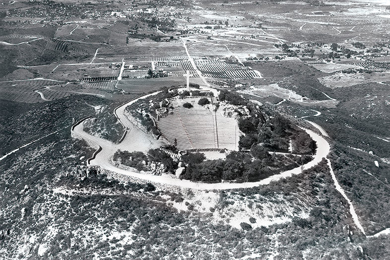
In 1924, Ed Fletcher gifted the six-acre cap of Mount Helix to a local family so they could build a memorial to their mother. The family received help from prominent San Diego architect Richard Requa, pioneer of the Southern California style, also known as Spanish Revival. This photo was taken after 1933, when the State Relief Administration (renamed the Civil Works Administration in 1934) hand-fitted the stone walls encompassing the Mount Helix Nature Theater and most of Mount Helix Drive. Now a county park, it is maintained by its trustee, Mt. Helix Park Foundation.
Vintage San Diego: How Our City Has Changed Since 1876
1938
La Jolla
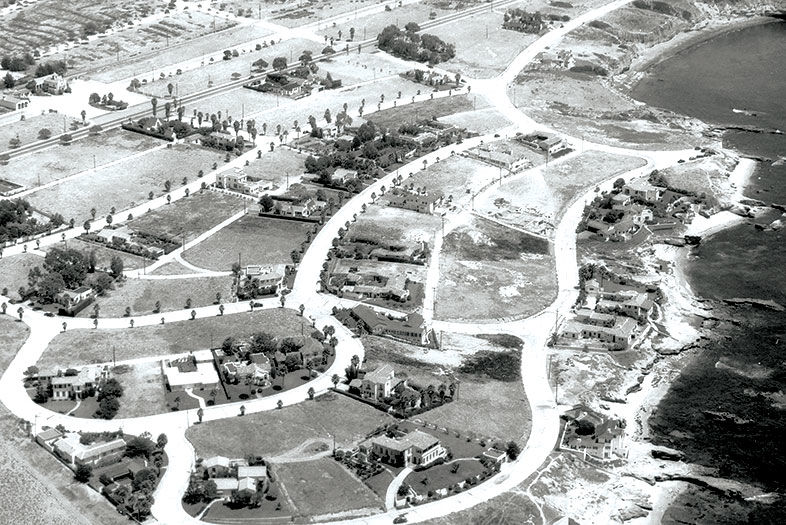
In the Lower Hermosa neighborhood south of Windansea Beach and north of Bird Rock, the road closest to the shore is Camino de la Costa. The house at the bottom right was brand new when this photo was taken, and is now listed on Redfin for $18 million. In 1938, the average cost of a home in the U.S. was $3,900, or about two times the average annual income. The straight, darker road running diagonally through the top of the photo is La Jolla Boulevard.
Note the large white lot to the east of it. The building is the San Carlos Electric Railroad Station, built in 1924 for the San Diego Electric Railway (the streetcar line), which ran until 1949. In 1953, the structure was purchased by the members of La Jolla United Methodist Church, which still operates there today. Later, they bought two buildings next door, La Plaza Mexican Restaurant and El Toro bar. According to the La Jolla Light, the first margarita in the U.S. was served in 1947 at La Plaza.
Vintage San Diego: How Our City Has Changed Since 1876
c. 1910
Imperial Beach Pier
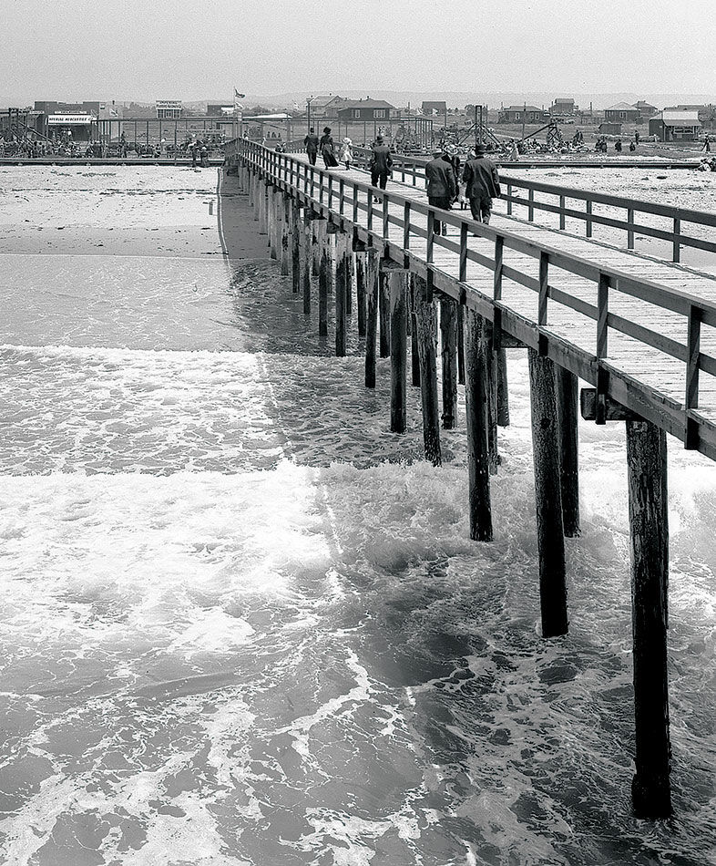
Imperial Beach got its name from developers attempting to entice those in the Imperial Valley to summer in this coastal area. At the time this photo was taken, the town had just laid down its first sidewalks and installed the pier, which was built in order to generate electricity for the town—machinery at the end of the pier harnessed the energy of the waves. But it didn’t work as well as planned, and was later dismantled.
Vintage San Diego: How Our City Has Changed Since 1876
1930
Hillcrest and North Park
Georgia Street Overpass
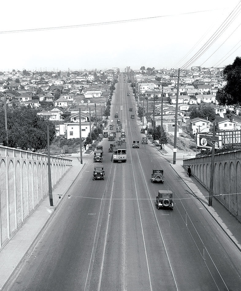
From the Georgia Street Bridge looking east on University Avenue, notice the streetcar passing Florida Street. Today a person can still enjoy a view from the bridge, which is undergoing a $14-million makeover to render it earthquake friendly. Scheduled to be completed next summer, the 102-year-old bridge, which was put on the National Register of Historic Places in 1998, will reinstate certain features, such as vintage-style lampposts.
Vintage San Diego: How Our City Has Changed Since 1876
1889
Escondido
Grand Avenue
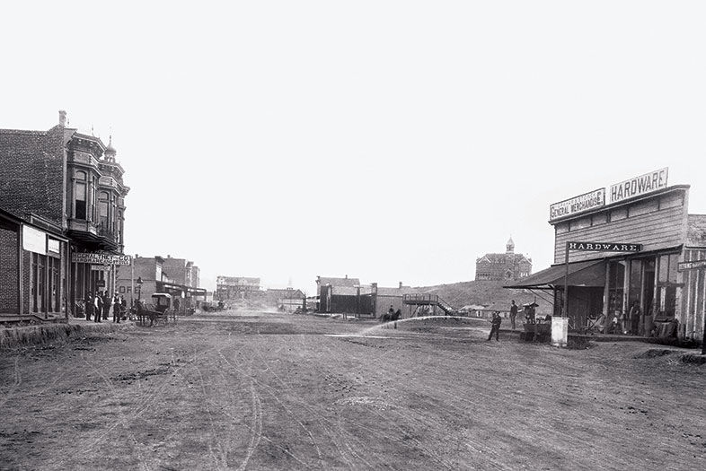
Once known as Rincon del Diablo, this area became Wolfskill Plains and then, officially, Escondido in 1884. The city was incorporated one year before this photo was taken. On what is still a main artery today, hardware stores, land agents, and a new 100-room hotel lined the wide avenue creased with wagon tracks. An extension of the Santa Fe railway was also a welcome addition. The same year, a San Diego tavern owner named Wyatt Earp helped judge a county fair horse race just north of town.
Vintage San Diego: How Our City Has Changed Since 1876
c. 1930
Hillcrest
University and Fifth Avenue
PARTNER CONTENT
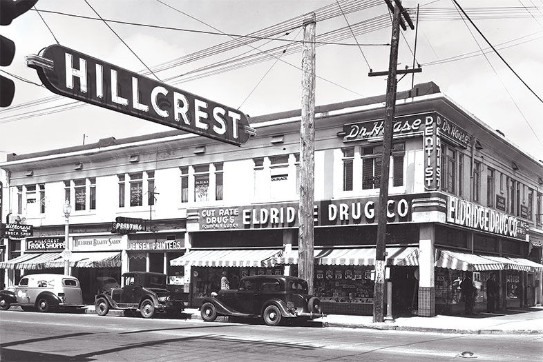
This community grew as downtown San Diego spread north in the late 1800s, calling for houses, apartments, and eventually retail—with extensive signage. Dentists don’t usually get neon signs, but as this photo shows, Dr. Haase did—as well as Eldridge Drug Co., offering “cut rate drugs” and a “fountain lunch.” Today on this corner you’ll find Vietnamese food, a tattoo parlor, vape lounge, and, where Eldridge stood, Perlman Clinic.


