Tijuana Slough National Wildlife Refuge
We all know that San Diego is blessed with nearly perfect weather all year long, but there are parts of the region that get too hot to hike in the summer and early fall.
San Diego County’s tallest peak, El Cajon Mountain, is actually closed in August because of extreme summer heat, and even shorter hikes such as Cowles Mountain and Mission Trails can be too challenging, especially for pets and young kids in 80+ degree weather.
Luckily, there are plenty of coastal hikes and running trails to hit when the temperatures rise. And, as a bonus, they come with great coastal views.
Torrey Pines
Sure, this place is obvious, but it’s also so beautiful and has so many cool coastal breezes that we can’t help but mention it. Plus, if you check the tides and go when the water is low, you can do a fun loop along the beach.
Start at the Torrey Pines Beach parking, head up the big hill to either the Beach or North Fork trailheads, and then head to Flat Rock, where you can descend to the beach. Walk along the sand back to the parking lot.
- Distance: 2.3 miles
- Difficulty: Moderate
- Refuel Spot: The Grill at Torrey Pines for upscale breakfast, sandwiches and salads, or dinner with a view | 11480 N Torrey Pines Rd, La Jolla, CA 92037
San Dieguito Lagoon
For a less crowded (and less pricey parking) option than Torrey Pines, explore the trails in the San Dieguito Lagoon. You don’t get the same sweeping ocean views, but it’s still so picturesque.
Start at the ranger station on Via de la Valle, and follow the Coast to Crest trail to the lookout over the lagoon. Then, if you still have energy, explore other paths such as the Riverpath or Dust Devil Nature Trail.
- Distance: 2.4 miles
- Difficulty: Easy
- Refuel Spot: Viewpoint Brewing for craft beers, tacos and salads, plus views of the lagoon | 2201 San Dieguito Dr Suite D, Del Mar, CA 92014
Aviara Lagoon Trail
Another great kid- and dog-friendly hike with cool breezes is the Lagoon Trail in Carlsbad along the Batiquitos Lagoon. Park on Gabbiano Lane and follow the trail past the nature center.
You can take it all the way to the end, and then loop back to follow the Eucalyptus Trail to add more distance. Along the way, there are scenic views and chances to see a range of birds, from herons to egrets and raptors.
- Distance: 3 miles
- Difficulty: Easy
- Refuel Spot: Beach Plum Kitchen for lemon ricotta pancakes, a breakfast biscuit sandwich, or the pork belly hash | 6971 El Camino Real, Carlsbad
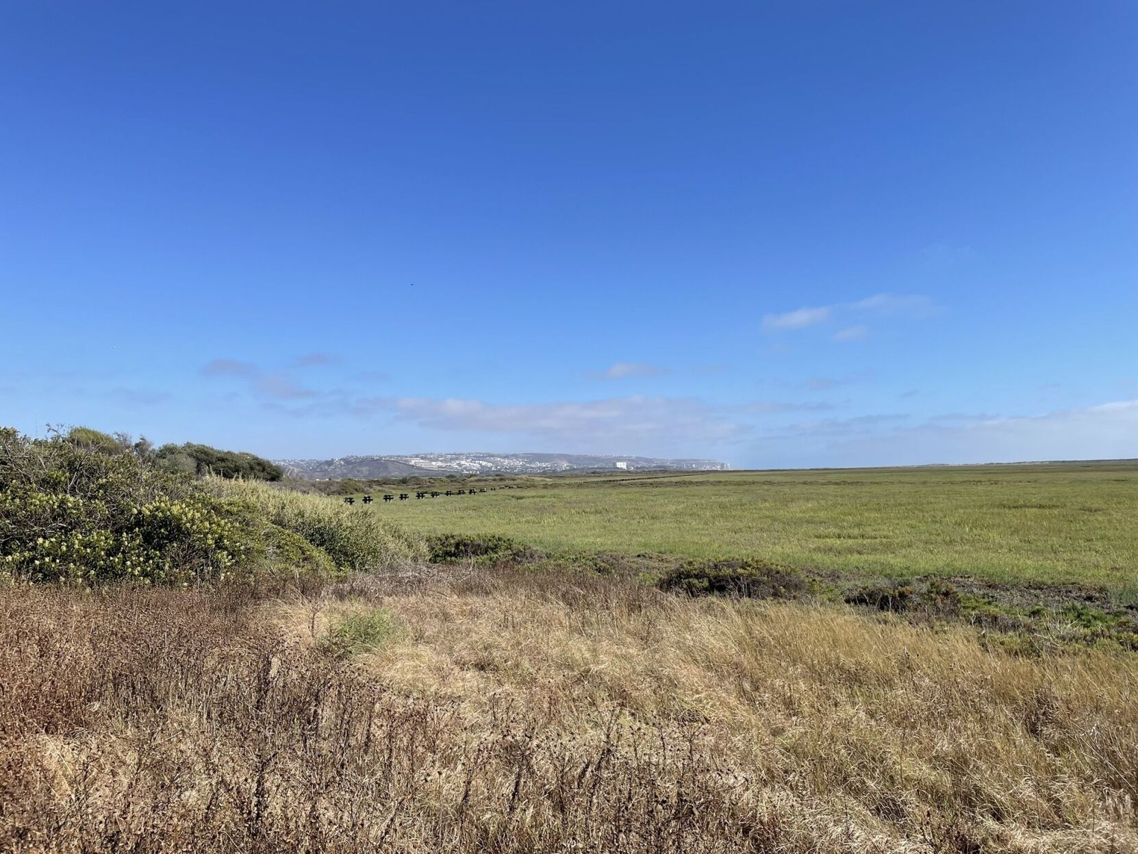
Tijuana Slough National Wildlife Refuge
A South Bay option that is right on the ocean and plenty cool has a network of flat, wide dirt trails weaving through beach scrub and over sand dunes. The trails take you through peaceful protected spaces with views of the ocean and Mexico in the distance.
Start at Iris Avenue and Tower Road in Imperial Beach. Follow the River Mouth Trail to the beach overlook, then extend your route on the out-and-back South McCoy Trail.
- Distance: 2.5 miles
- Difficulty: Easy
- Refuel Spot: SEA180 for a seafood brunch, with smoked salmon frittata or shrimp and grits | 800 Seacoast Dr., Imperial Beach
UCSD Run
These paths aren’t right on the ocean, but close enough to the coast to not get too toasty in the summer. There’s a network of relatively new bike paths and pedestrian bridges around the UC San Diego campus, including several protected bike paths fully off the road. Make sure to stop and take an instagram worthy shot of the two-toned blue pedestrian bridge on campus.
Start at the UTC mall and head north on Genessee Ave to the bike path. After you cross I-5, you’ll join up with a bike path that you can follow south until you hit Voigt Dr on the UCSD campus. Take the path through campus and over the pedestrian bridge to join Miramar St and then back to your start.
- Distance: 4 miles
- Difficulty: Easy
- Refuel Spot: True Food Kitchen, Queenstown Bistro, or Great Maple UTC, all in the UTC mall, have plenty of drinks, brunch and lunch options | Various Locations
Silver Strand Bike Path
There’s nowhere closer to the ocean than the Silver Strand path, with beautiful views of the ocean and marshes that stretches as long as you are willing to go. There are spots to stop along the way and take a water break or stand on a dock hanging over the water, so you can enjoy the ocean breeze and take in the sights.
Start near the Coronado Yacht Club and hop on the bike path, which you can follow for a full 24 mile loop, or turn back at any time.
- Distance: 24 miles
- Difficulty: Hard
- Refuel Spot: Get drinks on the patio of the Hotel Del, or for something lower key, get coffee and pastries at The Henry | 1031 Orange Ave, Coronado, CA 92118
Chula Vista Bayfront Sweetwater Bike Path
This bike path in Chula Vista lets you take advantage of cool ocean breezes and skirts the San Diego Bay National Wildlife Refuge while connecting Chula Vista’s Bayside Park with the Living Coast Discovery Center. Check out the pedestrian bridge, plus spots to stop and take in the San Diego Bay.
Start at Bayside Park and go north on the path, then run or ride just the new path, or use it as part of a longer ride along the bay.
- Distance: 1.5 miles
- Difficulty: Easy
- Refuel Spot: Get cold brew, avocado toast, or a drink called “Peanut Butter Cup” at Grindhouse Coffee | 260 1/2 Third Ave, Chula Vista, CA 91910
Marion Bear Park
This wooded path lets you through fields of flowers, and can connect you to the Rose Canyon Open Space Park, a canyon with beautiful views of cliffs and the train tracks below.
Park on Genesee Avenue near Governor Drive and follow the trail either east or west, or do a full loop. If you want more distance, follow the roads through UTC to join up with the Rose Canyon trail.
- Distance: 6 miles
- Difficulty: Hard
- Refuel Spot: Get pizza, salads and sandwiches at Urban Plates | 8707 Villa La Jolla Dr, La Jolla, CA 92037
