



Food News
Mabel’s Gone Fishing & Secret Sister Alums Opening All-Day...
Read article

Featured articles
Food News

Food & Drink

Food & Drink
Featured articles

Everything SD

Everything SD

Everything SD
Featured articles

Things to Do

Food & Drink

Things to Do
Featured articles

podcast-ep

video

podcast-ep
Featured articles
Features

Features

Features
Featured articles
Partner content
Food News
Partner content

With a potentially historic El Niño underway, local experts break down the science, the chances of a wet winter, and what locals should do to prepare
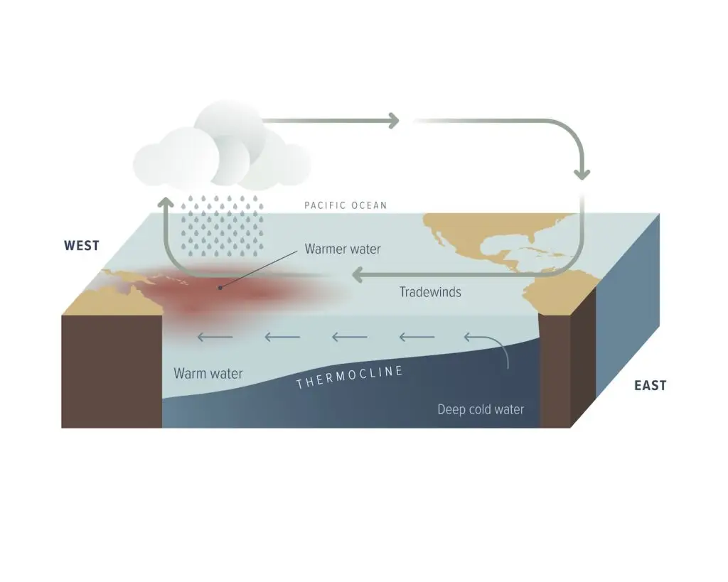
Imagine a Pacific Ocean–sized bathtub. The water on the surface is warm from the sun. The water below, cold.
Now place an equally massive fan on one edge of the tub. The wind pushes the warm surface water to the other end. As the warm water leaves, cold water rises to replace it.
If you shut that fan off, what happens? All that warm water starts sloshing back to where it started.
That’s an El Niño.
We’re months-deep into an El Niño that the National Oceanic and Atmospheric Administration (NOAA) says has a 75 percent chance of being the strongest since 1950. Sensationalist headline writers have coined it a “Super El Niño.” But when asked on the street, very few of us can explain it in simple terms. A few weeks ago, all I could tell you is that something happens somewhere that leads to rain.
So I asked a few experts to explain it to me like I’m 5 years old—and bathtubs and fans made the simplest sense. The bathtub is the Pacific Ocean. Asia is one edge, and the other edge is the Americas (for our purposes, San Diego). Typically, trade winds flow from east to west. That pushes San Diego’s warm surface water over to Asia, where it forms a resort-temp bath (called the Western Pacific Warm Pool).
That’s why countries like Indonesia are so rainy. First the warm ocean water evaporates in bulk. Next that moisture-loaded air rises, cools, and condenses into clouds (the Walker circulation). Then, rain.
In San Diego, when that top layer of warm water leaves, colder water rises up to replace it.
But in El Niño years, trade winds weaken (the fan slows down). All that warm surface water in Asia comes right back to San Diego. This is why water temps in La Jolla this summer were hot tub–level hot. In August, Scripps Institute of Oceanography recorded its highest ocean temperature in history (79.2 degrees), and a buoy off the coast of San Onofre registered 80.78 degrees—about 12 degrees warmer than the August average.
All of this increases the chance of rain in San Diego. Why?
First, let’s explain the Pacific jet stream. About 5 to 9 miles above us is a band of wind that generally blows from west to east, like a railroad for storms. In a typical winter, the track runs up north around Oregon, Washington, and southern Canada. That’s part of why Portland spends winter under a wet towel while San Diego sits smug and sunny.
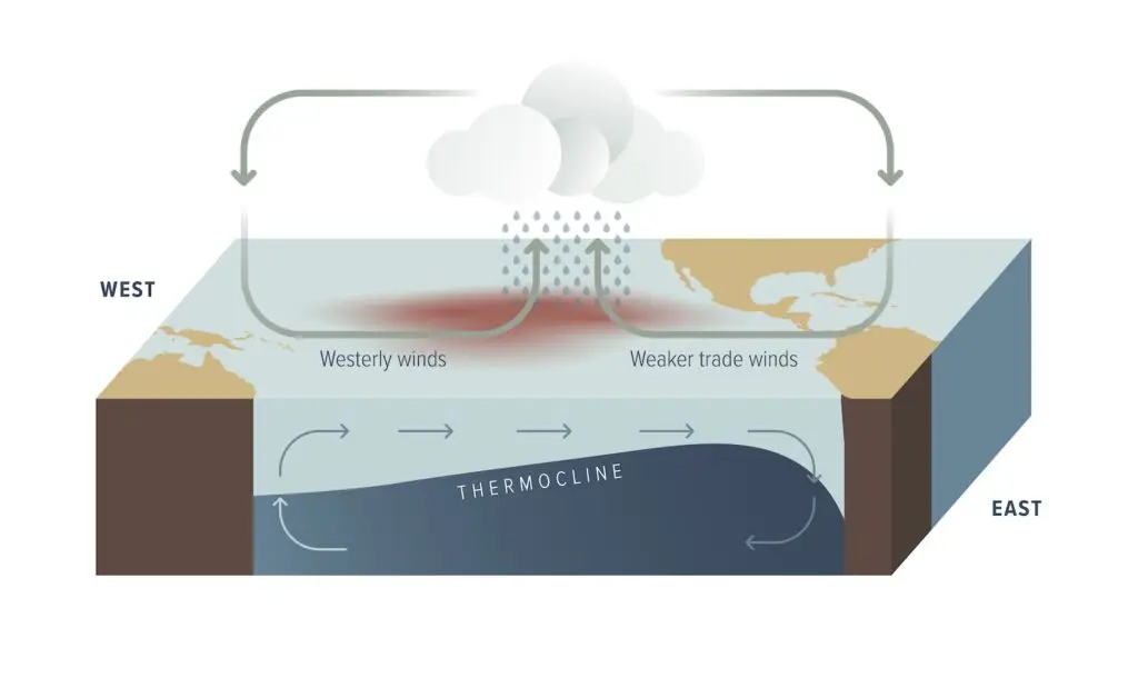
An El Niño moves the tracks south toward us. It doesn’t guarantee rain or storms; it just points the train in our direction.
Adam Roser, lead meteorologist for the National Weather Service’s San Diego outpost, points to the “Godzilla” El Niño of 2015. That year broke warming records in the central Pacific. Forecasters predicted drought-busting amounts of rain. And then—well, not much. It was an especially dry winter (even compared to non–El Niño years).
“A strong El Niño really just means we have very warm ocean temperatures along the equator,” he says. “This can drive different weather patterns across the area, but it definitely doesn’t guarantee [heavy rain].”
El Niño is Spanish for “little boy” or “Christ child” (the original full name was El Niño de Navidad.) And for centuries, humans have been trying to predict the boy’s arrival time and mood. While excavating a 500-year-old burial site in Peru, anthropologists surmised about 80 people participated in an Incan sacrifice to appease an angry god during a strong El Niño. The first written recording of an El Niño came in 1578, when Spanish surveyor Francisco de Alcocer documented changing weather patterns, widespread flooding, and landslides in Peru.
The whopper El Niño that San Diegans remember most—one of the most destructive in California history, according to the California Coastal Commission—came in 1997–1998. The airport recorded 180 percent more rain (17.78 inches total) than a typical season. Wet zones created a sinkhole near Interstate 15 and Balboa Avenue that was reportedly 550 feet long, 35 feet wide, and 65 feet deep. By mid-August, 23 El Niño–related emergency permits had been approved along the San Diego coast.
As I’m writing this, the media is hot-and-heavy covering a Kelvin wave headed for California. So let’s talk about it.
During an El Niño, some of the warm water from Asia comes back to the Americas as a massive, slow-moving bulge of water along the equator. That’s a Kelvin wave. It’s bulgy (it raises sea level by a few inches) because warm water expands more than cold water. It takes two to three months for a Kelvin wave to cross the Pacific; it’s often the warning sign of El Niño. When it finally hits South America, part of its energy turns and travels north along the coast which can hit California.
Kelvins aren’t great. San Diego’s coastline—largely sandstone cliffs—have been eroding since the beginning of time. But erosion has sped up in recent years, with multiple cliffs collapsing. A massive bulge of water doesn’t help.
The good news? Scientists are on it. Scripps’ California Mapping Program has surveyed the entire coastline every two years since early 2023. “To collect the data, we fly an aircraft equipped with a laser scanner that generates three-dimensional maps of the coast,” says coastal geomorphologist Adam Young. “We can compare the maps before and after the El Niño to measure how the coast changes.” The program is still relatively new and the team is analyzing its first studies, so Young can’t yet say how local coastlines will withstand this year’s El Niño. But data will come.
To simultaneously ward off fearmongering and peddle it, El Niños have always existed, are a normal part of living on earth, and can be expected every two to seven years. They’re the warming half of the El Niño–Southern Oscillation phenomenon (the cooling half is La Niña). Climate change, however, seems to be altering its frequency, intensity, and predictability.
“We’re continuing to see more extreme events,” Roser says. “Bigger amounts of rain in very little time [and] warmer water temperatures.”
This year’s version was labeled a Super El Niño. What makes it so super? Oceanographers track sea-surface temperatures, currents, and winds in real time along the central-to-eastern equatorial Pacific (in a US-sized plot of water called the Niño 3.4 region, between 120 and 170 degrees west longitude and 5 degrees south and 5 degrees north latitude).
In 2026, we were “weak” by June, “strong” by August, and “very strong” by September. By September 21, daily averages in the Niño 3.4 surpassed 3 degrees Celsius over average. That’s how we find ourselves in the not-seen-in-76-years, pretty-historic range.
In September, Governor Gavin Newsom declared a state of emergency for California to prioritize resources that prevent coastal erosion, flooding, and mudslides. At the San Diego Office of Emergency Services, Robert Rezende has weekly El Niño preparedness meetings with the National Weather Service and biweekly meetings with every department head for the entire city. “We talk about predictions and what we need to watch out for,” he says. “We have a lot of lessons learned from the past that we try to apply to the current plan, understanding that what’s going to happen [will be] a fluid situation that we have to address in the moment.”
Those preparedness meetings are lessons learned from the past, put into action. Rezende says this is the first time everyone (fire, lifeguard services, parks and recreation, anyone in disaster preparedness and resolution) has collaborated this closely. Proactivity drives these meetings. After noting that there are now more buildings, housing, and infrastructure—which redirect how water flows and floods—compared to previous El Niños, the stormwater department installed more water pumps where they didn’t exist before.
We can’t stop the warm water from sloshing back, but we can shore up our end of the tub.
“What we do know is that there is going to be some type of change in our normal weather pattern as to what would be a normal winter in San Diego,” Rezende says. “The question is, what is that going to look like?” We’ll just have to find out.
It’s hard to say which areas in San Diego are most vulnerable during any storm, Rezende explains. Only the gods know where rain will land. Obviously places near creeks, water, rivers, coastal zones—anywhere water flows downhill, especially near the bottom of that hill—are more at risk. Fashion Valley and Mission Valley malls have historically flooded because they’re built near the end of the San Diego River.
To prepare, Rezende recommends gathering information first: “Where’s my property sitting? Is it sitting in a floodplain? Is it sitting near a watershed? Historically, has there been water that has flooded my street, my house, my neighborhood?” (Not sure if you’re in a floodplain? Not sure what a floodplain is? Enter your address at sandiego.gov/elnino and find out.)
The next thing to do is establish an evacuation plan, taking pets and every family member into consideration. “You don’t want to come up with a plan when you have to move,” Rezende says. “Come up with a plan ahead of time.” Put your important documents into Ziploc bags and store them in a backpack or duffel, along with food for your pets, prescription medication, important photos—anything you don’t want to lose in the event of a flood. While you’re taking stock of the inside of your house, scan the outside, too. Is your roof equipped to sustain lots of rain? Are your gutters cleared? That’ll keep the rest of your house safe in rainy conditions.
Rezende also suggests signing up for two services: Alert San Diego and Genasys Protect. Alert San Diego is a county-based program where his office pushes messages directly to your phone via text, email, and phone call. Genasys Protect is how the police and fire departments push out messages to people in affected areas, like evacuation messages to people living in flood zones.
Emma Veidt is an editor at San Diego Magazine. She earned her bachelor's and master's degrees from the Missouri School of Journalism. She loves running, hiking, and rock climbing, but really, she mostly loves encounters with the street cats around North Park.
